If you’ve ever driven I-40 between Flagstaff and Winslow and spotted crumbling stone ruins on a desert ridge, you’ve already glimpsed one of Arizona’s most unsettling roadside stories. That cluster of broken walls sits above Canyon Diablo — and somewhere beneath them is the Apache Death Cave, a volcanic cavern tied to one of the most grim episodes in Arizona’s tribal history.
This guide covers everything: the Apache Death Cave photos worth seeking out, the 1878 legend in full, the eccentric showman who turned a massacre site into a zoo, what historians actually think happened, and how to visit the site safely today.
What Is Apache Death Cave?
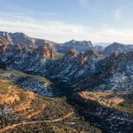
Apache Death Cave is a natural volcanic cave on the north rim of Canyon Diablo, located in the ghost town of Two Guns, Arizona — approximately 30 miles east of Flagstaff off old Route 66 (exit 230 on I-40). According to a widely repeated legend, Navajo warriors trapped and killed 42 Apache raiders inside this cave in 1878 by setting fire to the entrance. By the 1920s, the site became a Route 66 tourist attraction complete with a zoo, a trading post, and staged “cliff dwellings.” Today it’s an open-access ruin on Bureau of Land Management land, free to visit, and increasingly popular among Route 66 road trippers and ghost town photographers.
The 1878 Legend: What the Story Actually Says
The tale begins with a series of brutal Apache raids along the Little Colorado River. According to the most-told version of events — recorded in detail by Arizona writer Gladwell Richardson in his 1968 booklet Two Guns, Arizona — Apache warriors struck two Navajo camps in June 1878, killing nearly everyone. Three young Navajo girls survived, taken captive.
Navajo leaders sent a war party to track them down. For a time, the Apache raiders seemed to disappear entirely. Then, along the rim of Canyon Diablo, the Navajo pursuers noticed something strange: warm air and faint voices rising from a fissure in the ground. Looking down, they realized the Apache — horses, hostages, and all — were sheltering inside a volcanic cavern below.
What followed was ruthless and deliberate. The Navajo gathered sagebrush, piled it at the cave’s single entrance, and set it ablaze. Anyone who tried to break through was killed on the spot. Trapped, with no water left, the Apache reportedly slit their own horses’ throats — attempting to use the carcasses to smother the flames. It didn’t work. When the smoke finally cleared and the Navajo warriors entered the cave, they found 42 Apache men dead inside. They took back their stolen goods and left the bodies where they fell.
Local tribes said afterward that the land was cursed. Early settlers near Canyon Diablo reportedly heard moaning outside their cabins at night — though it’s worth noting that those accounts came well after the story had already been in circulation.
Two Guns: How a Cave Became a Roadside Attraction
The Cundiff Years (1914–1925)
The settlement later known as Two Guns started quietly enough. The Oldfield family homesteaded near Canyon Diablo around 1914, and by the early 1920s, Earle and Louise Cundiff had acquired roughly 320 acres and built a modest trading post, restaurant, gas station, and post office on the National Old Trails Highway. That road became US Route 66 in 1926 — and suddenly this remote corner of Arizona had traffic it had never imagined.
Henry “Crazy Thunder” Miller Changes Everything
In 1925, everything got stranger. A man named Harry E. Miller — who claimed to be a full-blooded Apache, called himself “Chief Crazy Thunder,” and wore his hair in long braids — leased land from the Cundiffs and immediately started building. With help from Hopi workers he hired off the reservation, Miller transformed the site into what he called Fort Two Guns: a zoo stocked with mountain lions, cougars, Gila monsters, and rattlesnakes; a stone trading post; living quarters; and most infamously, a “tourist cave” built right over the Apache Death Cave entrance.
He installed electric lights inside the cavern, built a concession stand near the entrance, and constructed fake cliff-dwelling ruins above the cave to make the whole thing feel more dramatic. He sold entry tickets from a stone booth that still stands (in ruin) today. He advertised the cavern as “Mystery Cave” or “Apache Caves” — and he allegedly sold the skeletal remains of the Apache found inside to souvenir-hungry travelers.
Miller’s time at Two Guns ended badly — even by frontier standards. In 1926, just one year after setting up, he shot and killed Earle Cundiff during a dispute over the lease terms. He was acquitted of murder. Shortly after, one of his own mountain lions mauled him. Then a Gila monster bit him. He eventually left Arizona, reportedly taking a significant amount of turquoise jewelry and silver merchandise with him on the way out.
The Decline of Two Guns
Two Guns limped along as a Route 66 stop through the mid-20th century, with new owners reopening the zoo at various points. But when Interstate 40 bypassed the old Route 66 alignment in the early 1970s, the traffic — and the town — died almost overnight. What’s left today is a remarkably intact layer cake of ruin: the Cundiffs’ stone structures, Miller’s zoo cages, a graffiti-covered gas station, a multi-stall latrine, and the cave entrance itself.
Myth vs. Reality: What Historians Actually Think
Here’s where things get complicated — and where a lot of online articles skip over the important nuance.
Virtually every detailed account of the 1878 massacre traces back to a single source: Gladwell Richardson’s 1968 booklet. Richardson was a prolific Arizona writer, but his work on Two Guns has never been corroborated by contemporary newspaper accounts, government records, or independent historical documentation. No 1878 records of a massacre at Canyon Diablo have surfaced.
Even Miller himself — the man who had the most to gain from sensationalizing the cave — never officially called it the “Death Cave.” His signs said “Apache Caves” and “Mystery Cave.” The name “Apache Death Cave” became the dominant label later, as the story passed through tourism writers and roadside-attraction guides.
Does that mean nothing happened here? Not necessarily. Navajo–Apache conflicts along the Little Colorado River were well-documented throughout the 1870s, and oral traditions from both tribes acknowledge violent encounters in the region. A volcanic cave at Canyon Diablo large enough to shelter a war party is real and verifiable. The core framework — an ambush, a pursuit, a cave — is entirely plausible given the historical context. But the specific details (42 dead, the horse-blood tactic, the three captive girls) likely grew with each retelling.
The honest answer is that we don’t know exactly what happened here. And that ambiguity is part of what makes the site so compelling to visit.
Apache Death Cave Photos: What You’ll Actually See
This is what most people come for — and the site genuinely delivers for photographers, even if the cave itself is more modest than the legend suggests.
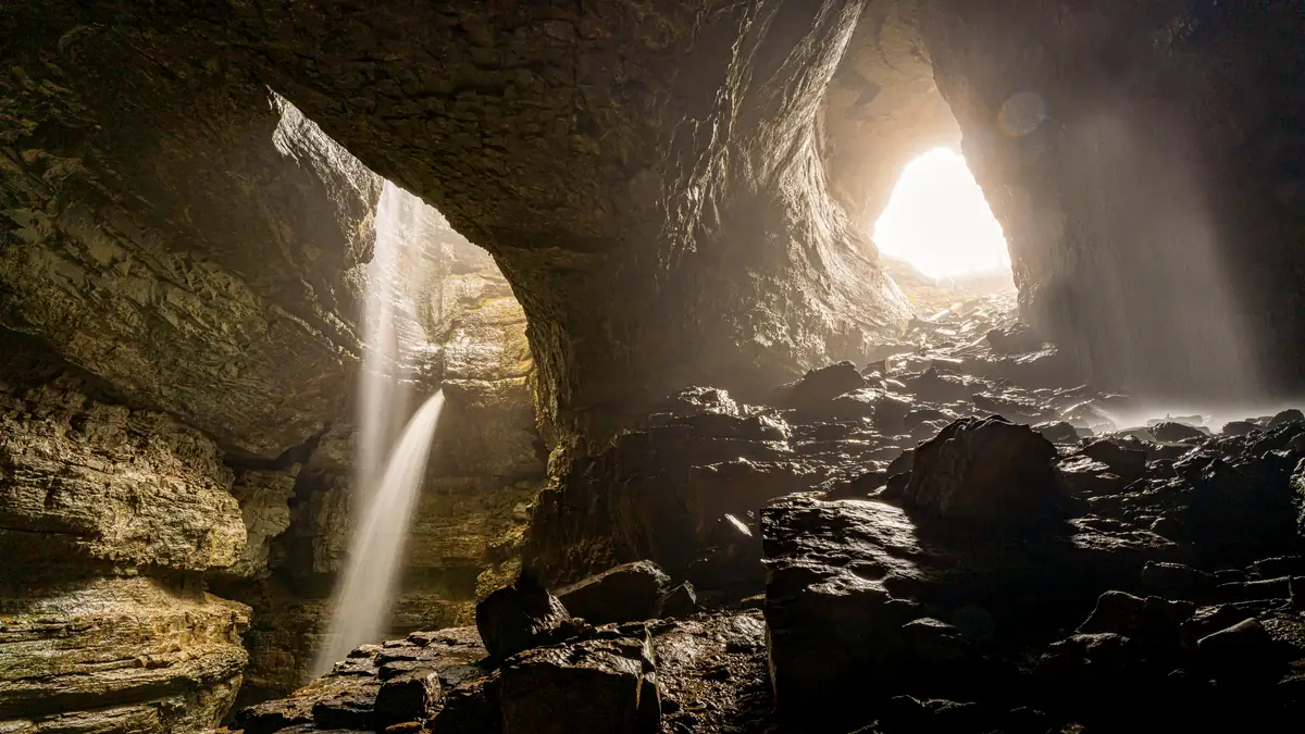
The Cave Entrance
The entrance to Apache Death Cave sits below a low stone structure (the old ticket booth Miller built in the 1920s). A wooden ramp leads down into the cave mouth — but be aware that this ramp has been deteriorating for years. Multiple travel writers and TripAdvisor reviewers have noted that it’s increasingly unstable. Take it slowly, test each board before committing your weight, and don’t attempt it in wet conditions or alone.
Inside, the cave opens into a dark chamber roughly large enough for a small group. The walls bear layers of graffiti going back decades — not ideal from a preservation standpoint, but visually interesting from a documentary photography angle. Without artificial light, it’s pitch black within about 20 feet of the entrance. Bring a flashlight or a headlamp; your phone light won’t be enough to shoot or navigate safely.
The Zoo Ruins
Miller’s mountain lion cages are among the most photogenic elements of the whole site. These are substantial kiln-like structures built from brick, mortar, and stone along the canyon rim — eerie and atmospheric in a way that a simple concrete ruin isn’t. The canyon drops off dramatically behind them, making for striking compositional depth.
The Gas Station
The graffiti-plastered gas station and service building are a Route 66 photography staple. The peeling paint, rusted pump bases, and broken windows photograph beautifully in the soft light of early morning or late afternoon. This is one of the most-photographed structures at the site, and for good reason.
Canyon Diablo Views
Don’t overlook the canyon itself. Canyon Diablo drops roughly 225 feet and stretches about 300 feet across — dramatic geology by any measure. The old bridge over the canyon is still accessible and provides an excellent vantage point. Looking west, on a clear day, you can see the raised rim of Meteor Crater on the horizon.
Photography Tips for Two Guns & Apache Death Cave
Timing: Golden hour (the 30–60 minutes after sunrise or before sunset) is ideal for the ruins. Midday sun creates harsh shadows that flatten the canyon walls. For cave interior shots, time of day matters less — you’re relying entirely on artificial light anyway.
Gear to bring:
- Flashlight or headlamp (essential for the cave)
- Wide-angle lens for canyon and zoo ruin compositions
- Tripod for low-light interiors and long-exposure dusk shots
- Extra batteries — there’s no power or charging anywhere nearby
Safety notes:
- The wooden ramp into the cave is unstable. Never descend alone.
- Watch for rattlesnakes, especially in warm months. The stone ruins are ideal shelter for them.
- Wear closed-toe shoes. The terrain is uneven and littered with broken concrete and rebar.
- Bring water. There is nothing to buy within miles of Two Guns.
Legal reminders:
- Two Guns sits on Bureau of Land Management land. Access is free and open.
- Removing artifacts — including any bone fragments or historical debris — is a federal offense under the Archaeological Resources Protection Act.
- Vandalism (adding to the graffiti) is illegal, even if it looks like everyone does it.
How to Get to Apache Death Cave
Address/Coordinates: Approximately 35.1177°N, 111.0958°W — search “Apache Death Cave” directly in Google Maps, which has the location pinned accurately.
From Flagstaff: Head east on I-40 approximately 30 miles to Exit 230 (Two Guns). Turn north and follow the dirt road. The ruins are visible within a few hundred yards.
From Winslow: Head west on I-40 approximately 20 miles to Exit 230.
Road conditions: The access road is unpaved but generally passable in a standard vehicle during dry conditions. After heavy rain, a high-clearance vehicle is advisable.
Nearby stops to combine: Meteor Crater Natural Landmark is just 5 miles east — well worth the entry fee. Winslow (the “Standing on the Corner” town from the Eagles song) is 20 minutes east. Flagstaff, with its extensive dining and lodging options, is 30 minutes west.
Visiting Two Guns: Practical At-a-Glance Info
| Detail | Info |
|---|---|
| Entry fee | Free (BLM land) |
| Hours | No official hours; daylight recommended |
| Parking | Informal dirt lot, no fee |
| Cell service | Limited; download offline maps |
| Restrooms | None (the old latrine is a ruin, not functional) |
| Nearest gas/food | Winslow (~20 mi east) or Flagstaff (~30 mi west) |
| Best season | Spring and fall (summer heat is extreme; winter can close dirt roads) |
| Time needed | 45 minutes to 2 hours |
Why Apache Death Cave Photos Matter Beyond the Legend
There’s a reason this site keeps drawing photographers, historians, and curious road trippers — and it isn’t just the gore of the legend.
Two Guns is a remarkable physical record of Route 66 boosterism at its most unfiltered. The fake cliff dwellings, the zoo cages built over a supposed mass grave, the electric lights installed in a volcanic cave to sell 25-cent admission tickets — it’s a condensed version of how the American West packaged its own violent past into entertainment for automobile tourists.
The cave photographs document that layering: Indigenous history (real or elaborated), frontier homesteading, 1920s showmanship, mid-century road culture, and eventual abandonment — all compressed into a few acres of Arizona desert. Whatever happened here in 1878, the story of what people did with that history afterward is worth understanding.
Conclusion
The Apache Death Cave is one of those rare places where history, legend, and landscape collapse into the same frame. Whether the 1878 massacre happened exactly as Richardson described, or whether some far messier and more human truth lies beneath the story, the site itself doesn’t lie: these ruins are real, the canyon is real, and the layers of exploitation and wonder that built up over the cave in the following century are absolutely documented.
If you’re driving Route 66 — or even just blasting down I-40 and looking for a reason to stop — Two Guns is worth the detour. Bring a flashlight, bring a camera, bring your skepticism about the legend, and bring respect for the history underneath it. The Apache Death Cave photos you take here will be some of the most atmospheric of your road trip, guaranteed.
Frequently Asked Questions
What is the Apache Death Cave?
Apache Death Cave is a volcanic cave near Two Guns, Arizona, on the rim of Canyon Diablo. It’s tied to an 1878 legend in which Navajo warriors trapped and killed 42 Apache raiders inside by setting fire to the entrance. Today it’s a free-access Route 66 historical site on BLM land.
Did 42 Apache warriors really die inside the cave?
That’s the most widely repeated figure, cited in sources including Atlas Obscura and Legends of America. However, historians note that all detailed accounts trace back to Gladwell Richardson’s 1968 booklet, with no corroborating contemporary records found to date. The story is plausible given the documented history of Navajo–Apache conflict in the region, but specific details remain unverified.
Where exactly is Apache Death Cave located?
It’s in Two Guns, Arizona, at approximately 35.1177°N, 111.0958°W — off Exit 230 on I-40, between Flagstaff and Winslow. Google Maps has the site accurately pinned under “Apache Death Cave.”
Can I visit and photograph Apache Death Cave?
Yes. The site is on Bureau of Land Management land with free, open access. You can photograph freely. Do not remove any artifacts — doing so is a federal offense. The wooden ramp into the cave is deteriorating; use caution and never descend alone.
Who was Chief Crazy Thunder?
Henry “Harry” E. Miller was a rancher and self-described showman who leased land at Two Guns in 1925, built a zoo over the cave entrance, and sold tours calling the site “Mystery Cave” or “Apache Caves.” He claimed to be full-blooded Apache and went by “Chief Crazy Thunder.” He shot and killed landowner Earle Cundiff in 1926, was acquitted, was subsequently mauled by his own mountain lion, and eventually left Arizona under a cloud.
Is Apache Death Cave actually haunted?
Early settlers near Canyon Diablo reported hearing moaning near the cave. There’s no scientific evidence for anything paranormal, but the site’s isolation and history — combined with the acoustics of a desert canyon — make it easy to understand why the ghost stories stuck.
Are there guided tours to Two Guns?
Most visitors explore independently. Some Route 66 tour companies and road trip guides include Two Guns as a stop. No admission fee, no tours, no ranger station — just the ruins and the canyon.
What should I bring to visit Apache Death Cave?
Flashlight or headlamp (essential), water (no services for miles), closed-toe shoes, a charged phone with offline maps downloaded, and optionally a wide-angle camera lens for the canyon views. A buddy is strongly recommended before descending into the cave.