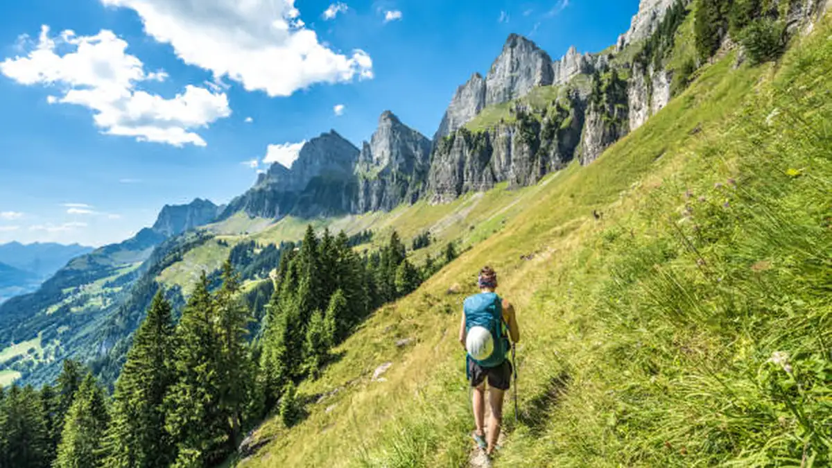
Most people picture Switzerland’s mountains from a train window. That’s a mistake. The country only really opens up once you’re on foot, above the tree line, with a hut still two hours away and cowbells the only sound around you.
Hiking in Switzerland means walking a signposted network of roughly 65,000 km of trails, graded on the SAC T1–T6 difficulty scale, running from gentle lakeside strolls to glacier-adjacent scrambles. Trains, postbuses, and cable cars reach almost every trailhead, and a dense system of staffed mountain huts makes multi-day treks possible without carrying camping gear.
Why Switzerland Is Built for Hiking
The Swiss delight in reminding you that the country’s roughly 62,500km of trails would be enough to wrap around the globe 1.5 times, and depending on which body is counting, other sources put the network closer to 65,000 km. Either number tells you the same thing: this isn’t a place with a handful of famous walks. It’s a place where hiking is basic infrastructure.
What separates hiking in Switzerland from hiking almost anywhere else isn’t the scenery alone — plenty of mountain ranges have glaciers and turquoise lakes. It’s the accessibility layered on top. Trailheads sit at the end of train lines. Cogwheel railways and gondolas carry you 1,000 vertical meters before you’ve taken a single step, so a demanding-looking route can still be a realistic half-day for someone with average fitness. And cable cars, cogwheel trains, and impeccably marked trails invite travelers to explore Switzerland’s heights with ease and confidence — though that same accessibility means the famous routes get busy in peak summer.
Every trail is waymarked using a national color system: yellow for standard walking paths, red-white-red for mountain trails requiring sturdier footwear, and blue-white-blue for demanding alpine routes needing full equipment and experience. Learn these three colors before you go and you’ll never accidentally wander onto terrain you’re not equipped for.
Understanding the SAC Difficulty Scale (Read This Before You Book Anything)
Nearly every guidebook, hut description, and trail app in Switzerland references the SAC hiking scale — a six-tier system running from T1 to T6. Ignore it and you risk ending up on a route that’s genuinely beyond you.
| Grade | What to expect | Suitable for |
|---|---|---|
| T1 | Wide, flat, obvious path | Anyone, including strollers in places |
| T2 | Gentle ascent, clear trail | Beginners, families |
| T3 | Steeper ground, some rocky sections, occasional exposure | Hikers with reasonable fitness |
| T4 | Scrambling, ladders/chains possible, real exposure | Experienced hikers, sure-footed |
| T5 | Technical terrain, route-finding required | Alpine experience essential |
| T6 | Glacier travel, pathless terrain | Mountaineers, often guided |
One detail trips up first-timers constantly: a grade describes the most demanding section of a route, not its average — a trail rated T3 has T3 conditions at its key points even if most of it is easy T2 walking. Conditions matter too. Grades assume dry terrain and clear visibility; wet grass, ice, or early-season snow can push a T3 into T4 or T5 territory overnight. If you’re new to Alpine hiking, stay in T1–T3 for your first trip and treat T4+ as something to grow into.
Best Regions for Hiking in Switzerland
Switzerland isn’t one hiking destination — it’s five or six, each with a different personality.
Bernese Oberland
This is the postcard region: Eiger, Mönch, and Jungfrau rising over Grindelwald, Wengen, Mürren, and the Lauterbrunnen Valley. Many people visiting on hiking trips to Switzerland base themselves in Interlaken, but staying instead in one of the villages nearby — Grindelwald, Mürren, Lauterbrunnen — delivers the same scenery with far fewer crowds. A Berner Oberland valley base also means earlier trailhead access without a drive or transit connection.
Valais (Zermatt & Saas-Fee)
Home to the Matterhorn and the highest concentration of 4,000-meter peaks in the Alps. Zermatt is one of the most popular bases for climbers, with more than 40 peaks over 4,000 meters in the surrounding region, but the valley also has excellent moderate hiking — the Five Lakes Walk chief among them. The Walker’s Haute Route finishes here after crossing from Chamonix.
Graubünden / Engadine
Quieter, with larch forests, sapphire lakes, and the wild Swiss National Park. This is where to go if the Bernese Oberland’s crowds put you off — the Swiss National Park is often so silent that the only sound you’ll hear is your own footsteps.
Lucerne
Home to Mount Rigi (“Queen of the Mountains”) and Mount Pilatus — both reachable by rail or gondola directly from the lakeside city, making this the easiest region to combine hiking with minimal travel logistics.
Appenzell
Rolling, green, and family-friendly. Rippling dairy country and flower-freckled meadows make this region a surefire winner with families, with gentle trails and villages that feel lifted from a storybook.
Ticino
Italian-speaking Switzerland, with a different climate and character entirely — chestnut forests, granite river gorges, and the popular but rewarding Sentiero Verzasca trail.
The Best Day Hikes in Switzerland
If you only have a handful of days, these are the routes that show off the country’s range:
- Faulhornweg (Bernese Oberland) — starts at First above Grindelwald and winds toward Bachalpsee, where the famous trio of peaks reflects on calm water, before ascending to Faulhorn at 2,681 m, home to one of the oldest mountain inns in the Alps.
- Oeschinensee Panorama Trail (Kandersteg) — a turquoise glacial lake ringed by cliffs; one of the most photographed short hikes in the country.
- Five Lakes Walk (Zermatt) — connects Lake Stellisee, Grindjisee, Grünsee, Moosjisee, and Leisee through a former glacial area, with the Matterhorn reflected in three of the lakes.
- Eiger Trail (Grindelwald) — a route along the base of the Eiger’s world-famous North Face, short but atmospheric.
- Mount Rigi Panorama Trail (Lucerne) — panoramic views stretching across Lake Lucerne and beyond, best tackled from late spring to early autumn.
- Creux du Van (Neuchâtel) — a dramatic natural rock amphitheater, roughly four and a half hours round trip.
- Hardergrat Ridge (Interlaken) — for experienced hikers only: a narrow ridge trail with steep drop-offs, roughly six hours for fit hikers, with a resident ibex colony near Augstmatthorn peak.
Quick Takeaway: If you want maximum reward for moderate effort, prioritize Faulhornweg or Oeschinensee. If you want a genuine physical challenge with exposure, Hardergrat is the benchmark — but it’s T4, not a casual outing.
Multi-Day and Hut-to-Hut Treks
Switzerland’s long-distance trails are where the country’s hut network really pays off — you carry a daypack, not a tent, and sleep in staffed accommodation every night.
- Via Alpina (Swiss Alpine Pass Route) — strings together 14 mountain passes across 18 stages from Sargans to Montreux, staying entirely within Switzerland. A 9-day “Bear Trek” section covers the Bernese Oberland highlights for those without three weeks free.
- Walker’s Haute Route — the classic Chamonix-to-Zermatt traverse linking the Mont Blanc and Matterhorn massifs, widely considered the most iconic multi-day trek in the Alps.
- Bernina Trek (Graubünden) — a four-to-six-day loop past turquoise lakes and the towering Piz Bernina (4,049 m), staying in huts like Cabane Rambert, that crosses between Switzerland’s Alpine north and Italian-speaking south.
How the hut system actually works: Most high-mountain huts are run by the Swiss Alpine Club, providing a dormitory bunk, blankets, and hot meals, so you hike with a light daypack rather than camping gear. Bring a sleeping bag liner and indoor shoes, expect communal tables, and carry cash — many huts don’t take cards. Popular SAC huts on Bernese Oberland and Valais stages fill six to ten weeks ahead in July and August, so book your beds before you book flights, not after.
A typical stage runs 5–7 hours with 800–1,200 m of climbing to a pass, then a descent to the next hut. Elevation gain matters far more than distance — a 12 km day with 1,100 m of ascent is significantly harder than a flat 20 km walk, which is why Swiss trail signs show time rather than distance. Breakfast at most huts runs 6:00–7:30 AM, and there’s typically no restaurant service mid-trail, so lunch is whatever you’re carrying — bread, cheese, dried meat, and chocolate bought in the valley the day before.
When to Go: A Month-by-Month Breakdown
| Month | Conditions | Best for |
|---|---|---|
| June | 14–20°C at altitude; snow can persist above 2,500 m through mid-month as huts begin opening | Valley walks, wildflowers, fewer crowds |
| July | Warm, long days, huts fully open | Classic high routes, but book huts early |
| August | 16–22°C with the most stable conditions of the year, though visitor volumes peak | Technical routes, multi-day treks — expect crowds |
| September | 12–20°C with stable high pressure and the year’s clearest visibility; crowds thin as school holidays end | Best overall balance of weather and solitude |
| October | 6–14°C, first snow possible on high passes, most SAC huts shut by mid-month, larch forests turn gold | Lower-altitude valley routes, autumn color |
| Nov–May | High Alps largely closed to hiking | Snowshoeing, valley trails at lower elevation only |
If certainty matters most, go in July and book huts months ahead. If you’d rather trade a slightly shorter window for thinner crowds and equally reliable weather, late June or early September gives the best balance.
Getting There, Getting Around, and What It Actually Costs
One of Switzerland’s genuine advantages over other Alpine countries is that you rarely need a car. Trains and postbuses reach an extraordinary number of trailheads, so you can hike point-to-point without driving. A Swiss Travel Pass or Half-Fare Card cuts costs meaningfully if you’re moving between regions, and most cable cars and cogwheel railways honor rail discounts too.
Budget realistically: SAC hut half-board typically runs CHF 70–120 per night; a packed trail lunch costs CHF 12–18; and cable car ascents to popular trailheads range from CHF 30–80 round trip depending on the mountain. Valley accommodation (Gasthof or Ferienwohnung) varies widely by region and season, with August commanding the highest prices.
What to Pack and How to Stay Safe
Sturdy boots with ankle support, layered clothing, sunscreen (UV is stronger at altitude), and enough water and snacks — weather conditions can turn quickly, so it’s essential to pack appropriately and prioritize safety. A portable water filter is genuinely useful on multi-day routes where refilling from streams is the norm.
Weather deserves particular respect above 2,000 m. A cloudless morning can become a full thunderstorm by early afternoon, especially in July and August, and the general rule on any high route is to be past the day’s highest point by 1:00 PM if storms are forecast. Check MeteoSwiss before you leave, watch the sky as you climb, and don’t be too proud to turn back.
Conclusion
Hiking in Switzerland rewards a bit of upfront planning more than almost anywhere else in the Alps — understand the SAC scale, book your huts early for July and August, and match the region to what you actually want (crowds and iconic views in the Bernese Oberland, solitude in Graubünden, gentle family trails in Appenzell). Do that, and the trail network takes care of the rest. Start by picking one region for your first trip rather than trying to cover the whole country — you’ll get a far better trip out of three days done well than seven days rushed.
For more hiking and outdoor adventure guides, browse our full collection of travel guides.
FAQ Section
Is Switzerland good for hiking?
Yes — it’s widely considered one of the best-organized hiking countries in the world, with roughly 65,000 km of signposted trails, reliable public transport to trailheads, and a dense mountain hut network that removes the need for camping gear.
How many days do you need to hike in Switzerland?
A satisfying first trip runs 4–7 days based in one region, like the Bernese Oberland. Multi-day treks like the Via Alpina Bear Trek take about 9 days; the full Via Alpina is around 18 days.
What is the SAC hiking scale?
A six-tier difficulty system (T1–T6) used across Switzerland, from T1 easy walking paths to T6 glacier travel requiring mountaineering experience. Most day hikers stay within T1–T3.
Do you need to book mountain huts in advance?
Yes, especially for July and August — popular SAC huts on routes like the Haute Route and Via Alpina fill 6–10 weeks ahead. September is more flexible but huts start closing late in the month.
What is the best region for hiking in Switzerland?
The Bernese Oberland is the classic choice for dramatic scenery and easy access; Graubünden/Engadine suits hikers wanting fewer crowds; Zermatt/Valais suits those chasing high-altitude views of the Matterhorn.
Can beginners hike in the Swiss Alps?
Absolutely. T1–T2 trails are wide, well-marked, and gentle, and many resort areas have dedicated family-friendly routes. Save T4+ terrain for once you’ve built up experience.
What should I pack for a Swiss hike?
Sturdy boots, layered clothing, sunscreen, a refillable water bottle or filter, and — for hut stays — a sleeping bag liner, indoor shoes, and cash, since many huts don’t accept cards.
Is hiking in Switzerland expensive?
It can be, particularly for huts, cable cars, and accommodation in July–August. A Swiss Travel Pass or Half-Fare Card, shoulder-season timing, and self-carried lunches all bring costs down significantly.